
Navigator X
Explore our custom map below, developed by Eco-index to help our local community interested in restoring their local ecosystem.
Custom Mapping for Ecosystem Reconstruction
Zoom in and use the Control panel (left) to toggle layers on and off.
Please note: Map is best viewed on a computer screen - mobile can be difficult.
Ecological Restoration from Scratch
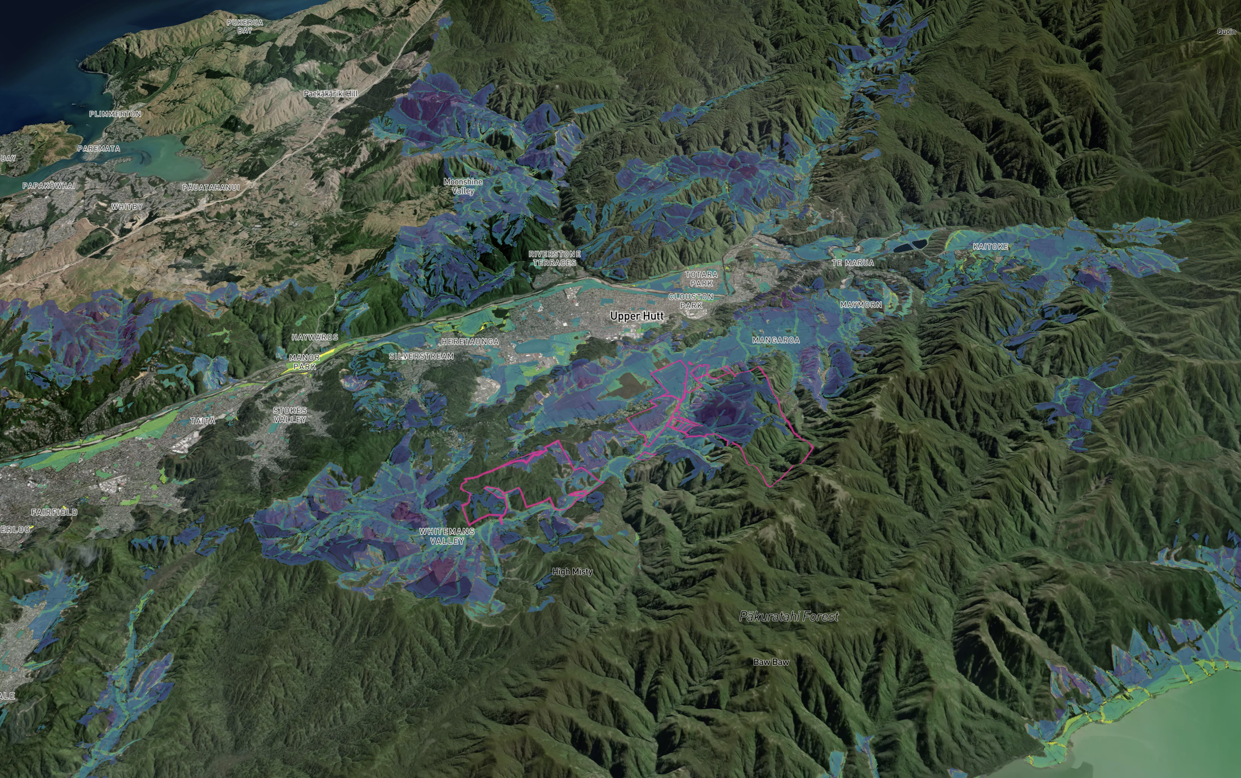
This custom map has been developed for Mangaroa Farms by Eco-index to help us undertake our local ecosystem reconstruction. Ecosystem reconstruction is a specific kind of ecological restoration where native ecosystems are rebuilt from scratch.
Navigator X uses a “heat map” approach to show the best bang-for-buck locations to undertake ecosystem reconstruction, based on the following priorities (click “+” to read more):
Prioritisation Options (See Control Panel on Map)
-
Priority is given to areas where reconstruction will create a stepping stone to improve ecosystem connectivity between existing native ecosystems. Ecosystem connectivity is important to allow species migration.
-
Priority is given to reconstruction areas that will contribute towards the goal of 15% cover of each native ecosystem type in each catchment. See Eco-index 15% rationale.
-
Priority is given to areas that are most susceptible to landslides according to the Highly Erodible Land database.
-
Reconstruction in areas that are already legally protected will save on legal costs and provide greater assurance that the work will be protected.
-
Priority is given to areas that are close to existing native vegetation. Existing vegetation can benefit ecosystem reconstruction projects by providing flora and fauna to help establish a desirable native ecosystem type.
-
Priority is given to areas that round out existing native vegetation patches. These areas have the potential to reduce edge effects and therefore help to stabilise the internal climate and habitat for flora and fauna.
-
Priority is given to areas that could protect a Department of Conservation Ecosystem Management Unit, DOC Reserve or QEII covenant.
-
Priority is given to areas that are likely to have relatively low land purchase costs and/or lower economic opportunity costs to retire for ecosystem reconstruction.
-
Priority is given to areas that are within 30 metres of the centreline of a river. This maximises benefits towards smaller waterways as they have the greatest potential for downstream benefits and in-stream shade when protected by riparian buffer planting.
-
Based on the Threatened Environment Classifications. Priority is given to the more threatened environments.
Information provided by Navigator X should be considered alongside local knowledge and other information sources. Please read the FAQs below for more information:
FAQs
-
Ecosystem reconstruction is the rebuilding of nature where native species have been removed or very disrupted. Ecosystem reconstruction is a specific kind of ecological restoration. For example, native tree planting in retired pasture is a common first step in lowland ecosystem reconstruction.
According to the international Society for Ecological Restoration, ecosystem reconstruction is "a restoration approach where arrival of the appropriate biota is entirely or almost entirely dependent upon human agency as they cannot regenerate or recolonize within feasible time frames, even after expert assisted regeneration interventions." -
The reconstruction priorities are based on custom or public data sets that are applicable across the whole of Aotearoa New Zealand.
Connectivity: Priority is given to areas where reconstruction will create a stepping stone to improve ecosystem connectivity between existing native ecosystems. Ecosystem connectivity is important to allow species migration.
Ecosystem 15% Cover Goal: Priority is given to reconstruction areas that will contribute towards the goal of 15% cover of each native ecosystem type in each catchment. See Eco-index 15% rationale.
Land Stability: priority is given to areas that are most susceptible to landslides according to the Highly Erodible Land database. Reconstruction of native ecosystems on erodible land can benefit land stability.
Legal Protection: reconstruction in areas that are already legally protected will save on legal costs and provide greater assurance that the work will be protected.
Native Vegetation Proximity: priority is given to areas that are close to existing native vegetation. Existing vegetation can benefit ecosystem reconstruction projects by providing flora and fauna to help establish a desirable native ecosystem type.
Native Vegetation Shape Improvement: priority is given to areas that round out existing native vegetation patches. These areas have the potential to reduce edge effects and therefore help to stabilise the internal climate and habitat for flora and fauna.
Protective Buffer: priority is given to areas that could protect a Department of Conservation Ecosystem Management Unit, DOC Reserve or QEII covenant.
Relative Affordability: priority is given to areas that are likely to have relatively low land purchase costs and/or lower economic opportunity costs to retire for ecosystem reconstruction.
Riparian Benefit: priority is given to areas that are within 30 metres of the centreline of a river. This maximises benefits towards smaller waterways as they have the greatest potential for downstream benefits and in-stream shade when protected by riparian buffer planting.
Threatened Environments: based on the Threatened Environment Classifications. Priority is given to the most threatened environments.
-
Each 10x10m pixel in Navigator X has been scored for each reconstruction priority (Threatened Environments, Connectivity, Ecosystem 15% Cover Goal, Native Vegetation Proximity, Legal Protection, Relative Affordability, Riparian Benefit, Native Vegetation Shape Improvement, Protective Buffer & Land Stability).
The higher the score, the better that location is for ecosystem reconstruction and the brighter the colour on the map.
-
If you’re working on a computer, please allow third party cookies.
We are not able to optimise Navigator X for mobiles due to to the size and complexity of the data, apologies for any inconvenience. -
Finding the best bang-for-buck locations to undertake ecosystem reconstruction.
Toggling on/off the prioritisation options based on your own preferences.
Exploring ecosystem reconstruction options on a 3D map.
Exploring contextual information to support decision-making.
-
The information provided in Navigator X is as accurate as possible with the available data sources, but it is still subject to uncertainty. We encourage land managers and decision makers to combine this information with other available guidance. We also recommend ground-truthing guidance from Navigator X in your catchment before planning any work. Eco-index is not responsible for how this information is applied or any loss, damage or expense arising from such use or reliance.
-
Biodiversity is a term used to describe the enormous variety of life on Earth. Our economy and society are embedded in nature & biodiversity, not external to it. In summary, biodiversity underpins Aotearoa New Zealand’s economy and society.
We know that native biodiversity in this country (like many others) is not doing well. If we want our society and economy to be healthy, it is logical to reduce the decline of native biodiversity.
Read more here:
Why nature matters - Taskforce for Nature-related Financial Disclosures
-
In many areas, Aotearoa New Zealand’s native biodiversity is dramatically lower than the safe lower limit needed for the ecological processes we depend upon. In addition, the location of native ecosystems across the country is very skewed with some ecosystem types much more reduced in extent than others.
We need native ecosystems like forests and wetlands to produce valuable services like reduced erosion, flooding, carbon emissions, air, soil and water pollution, non-native species spread, and also to provide for people’s physical and mental wellbeing.
In short, undertaking ecosystem reconstruction will bring benefits to your land and people.
More information:
-
Navigator X is derived from the Eco-index Navigator - a specialist GIS product.
The Eco-index Navigator analyses a stack of spatial data layers that have either been developed by the Eco-index team or are publicly available, such as:
-
Unfortunately no, information cannot be downloaded from Navigator X but you can take screenshots.
-
Regenerating or mature ecosystems are present in the areas that are not coloured by the prioritisation options. See the Land Cover Snapshot in the Contextual Info panel.
The prioritisation options focus on areas suitable for ecosystem reconstruction (i.e. from scratch). Areas with regenerating or mature ecosystems are important places for protection and restoration but are usually not suitable for ecosystem reconstruction. -
Navigator X is operated in a similar way to Google Earth. You can zoom in and out, rotate, drag and tilt the map using a computer mouse (both left and right buttons), keyboard arrow keys or normal controls for a tablet.
Want to know more?
Get in touch here.